Directions to the Property:

From LaPaz, take Transpeninsular Highway 1 (also known as Carratera LaPaz-Ciudad Constitucion) westerly out of LaPaz. The highway is located just to the north of the LaPaz airport. When you reach the outskirts, bear left at the junction. Below is a picture showing the airport and the highway. Note that “Ctra La Paz-Ciudad Constitucion” turns left just on the outskirts.

Once on the highway, follow the road to KM marker 140. The route is shown below.

At approximately KM marker 120 (unsure of exact mile marker, but approximately 120), there will be a new electric substation on the left (west) side of the road. A picture of the substation is below.

From this point, you will pass a small store, on the left, at approximately KM marker 130. The road at this point is a long straight away. Stay on the road until KM 140. The highway bends to the right at this point, and the entrance is just before or at the curve to the right. This is where you turn left onto the property. There is a green sign just inside the fence line on the left side that says “Loma Amarilla”. Turn left at this sign. A picture of the sign is below.

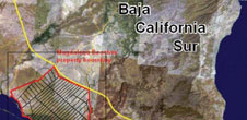
From this point, it is approximately 12.1 miles (19.5 km) to the shrimp farm basins. Luis Vega says the Loma Amarilla road is subject to washouts and may be sandy in some areas, however, it should be passable in (preferably) a four wheel drive vehicle or a truck. Luis would not use a passenger car or sedan to enter this area. Once you reach the shrimp farm, there is a fairly well defined road that runs along the rear of the ponds, then moves toward the mangroves just below the shrimp farm. This road continues generally south along the edge of the mangroves all the way to the dune area. Again, this road may be subject to washes and care should be taken when driving along here. Below is a picture of the route (white line) that should provide access to the various areas.